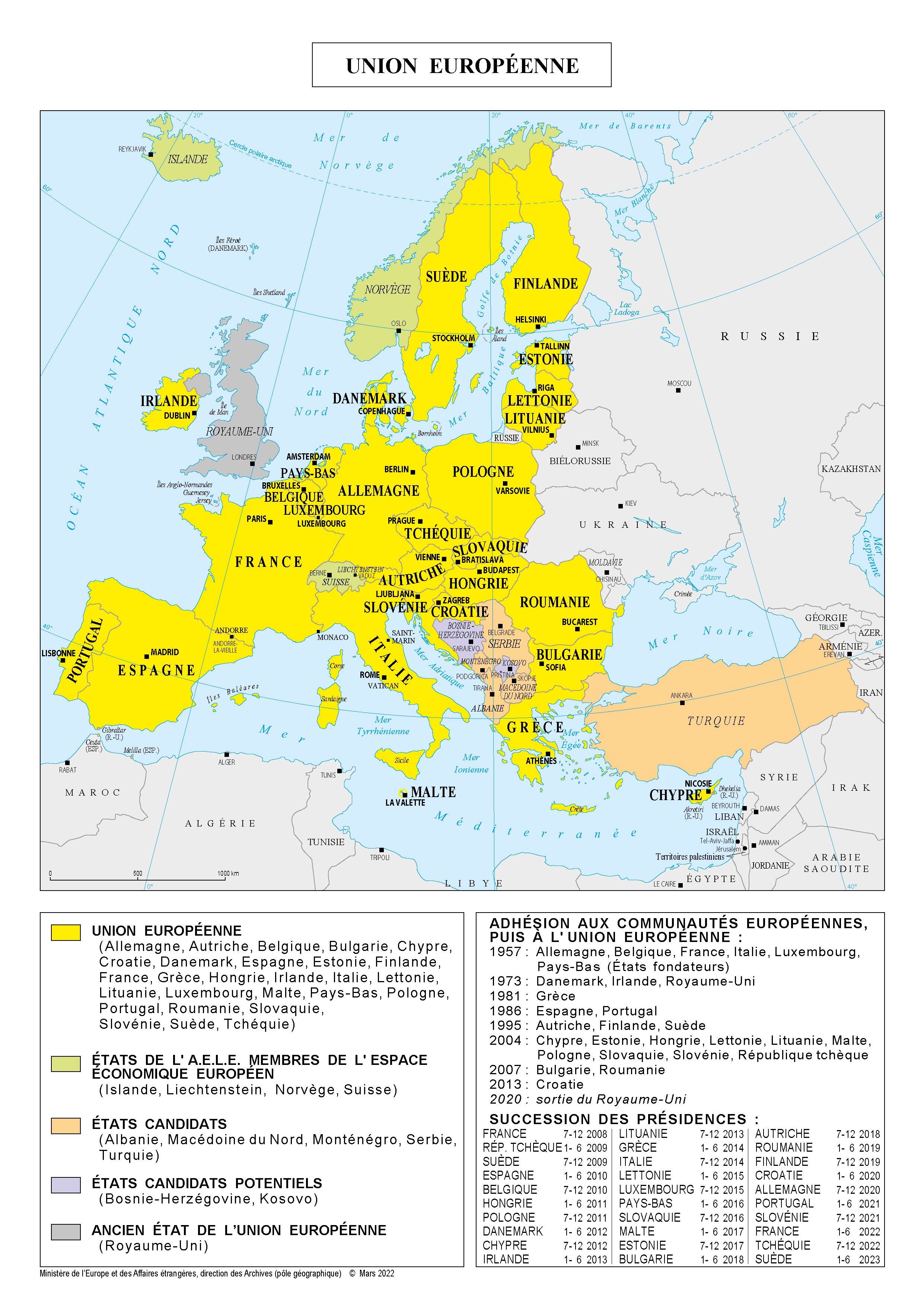
Geography
Area : 3,989,180 km² Coastline: around 80,000 km (EU), 42,673 km (Schengen Area)
Borders : null
Flag
Population
Population : 448,387,872 (2023)
Crude natural change rate : -2.6‰ (2023)
Population repartition: 15 years of age 14.9% (2023), 65 years of age 21.3% (2023)
Foreign residents: 37.5 million (2021)
Crude net migration rate: 8.9‰ (2022)
First time asylum applicants: 912.000 (2024)
Life expectancy: men 78.9 years, women 84.2 years (2023)
Birth rate: 8.2‰ (2023)
Death rate: 8.2‰ (2023)
Total positive applications: 8.2‰ (2023)
Source : Eurostat, Ined, Insee
Economy
GDP: €17 000 030 million (2025)
GDP per capita (PPS): €39 980 (2025)
GDP growth : 0.5% (2025)
Inflation: 2.2% (November 2025)
Public debt: €17 710 682 (2025)
Unemployment: 6.4% (December 2025)
Stock of foreign direct investment from the entire world: 6.5% of GDP (2024)
Public debt: 49.5% of GDP (2025)
Government revenues: 46.2% of GDP (2025)
Exports outside of the EU: €228.2 billion (September 2025)
importationsHorsUE: €211.9 billion (September 2025)
Trade balance: €+12.102.050 million (Q3 2025)
Source : Eurostat and OECD, Trading Economics, Access2Market statistics
Political system
Political representation
Euro Area Member Countries: 21 Member States of the European Union take part in the Single Currency
- Austria
- Belgium
- Croatia
- Cyprus
- Estonia
- Finland
- France
- Germany
- Greece
- Ireland
- Italy
- Latvia
- Lithuania
- Luxembourg
- Malta
- Netherlands
- Portugal
- Slovakia
- Slovenia
- Spain
- Bulgaria
Women's representations
On The Same Theme
Country Sheet
Country Sheet
Country Sheet
Country Sheet
Country Sheet
Country Sheet
Country Sheet
Country Sheet